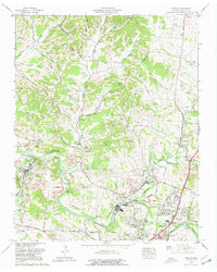
1965 Map of Godwin
USGS Topo · Published 1980About this map
Industrial and agricultural landscapes intersect in this mid-century portrait of Maury County, where the Duck River carves distinct features like White Bend and Alexander Bend. The northern reach of Columbia is visible, showing the expansion of neighborhoods such as Royal Oaks and Jackson Heights. A network of country roads, including the Theta Pike and Columbia Construction Pike, connects family-named landmarks and rural congregations like Knob Creek Church and Friendship Ch.
Find a feature on this map
87 named features on this map. Tap any name to fly to it.
Don’t see what you’re looking for? This feature index may not catch every label — zoom into the map to look around manually.
Map Details
Editions of this 1965 Godwin Map
3 editions found
Other maps of this area

1901 · Colombia
USGS Topo · 1:125,000

1909 · Franklin
USGS Topo · 1:62,500

1936 · Godwin
USGS Topo · 1:24,000

1936 · Williamsport
USGS Topo · 1:24,000

1936 · Primm
USGS Topo · 1:24,000

1936 · Spring Hill
USGS Topo · 1:24,000

1936 · Theta
USGS Topo · 1:24,000

1936 · Carters Creek
USGS Topo · 1:24,000

1936 · Mount Pleasant
USGS Topo · 1:24,000

1936 · Glendale
USGS Topo · 1:24,000