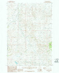
1987 Map of Goff Lake
USGS Topo · Published 1987About this map
Heart Mountain rises as a prominent landmark in this corner of Park County, where the high desert terrain transitions toward the Absaroka Range. The landscape is defined by an intricate network of drainages, including Pat O'Hara Creek, Skull Creek, and Cottonwood Creek, which converge as they flow toward the Bighorn Basin. In the late 1980s, the area remained largely undeveloped, characterized by open range and infrastructure such as a Trans line and a buried Pipeline.
Find a feature on this map
17 named features on this map. Tap any name to fly to it.
Don’t see what you’re looking for? This feature index may not catch every label — zoom into the map to look around manually.
Map Details
Editions of this 1987 Goff Lake Map
This is the sole edition of this map. No revisions or reprints were ever made.
Other maps of this area

1949 · Pat O'Hara Mountain
USGS Topo · 1:62,500

1949 · Cody
USGS Topo · 1:62,500

1950 · Clark
USGS Topo · 1:62,500

1950 · Deep Lake
USGS Topo · 1:62,500

1951 · Cody
USGS Topo · 1:62,500

1955 · Cody
USGS Topo · 1:250,000

1958 · Cody
USGS Topo · 1:250,000

1962 · Cody
USGS Topo · 1:250,000

1980 · Cody
USGS Topo · 1:100,000
1987 · Cody
USGS Topo · 1:24,000