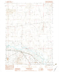
1983 Map of Golconda Butte
USGS Topo · Published 1983About this map
The Humboldt River snakes through this high desert basin, defining a complex corridor of seasonal waterways and marshlands in northern Nevada. The landscape is characterized by the braided channels of Pioneer Slough and The Island Slough, which surround a distinct landform known simply as The Island. This hydrological network supported early transit routes across the Great Basin, later followed by the Southern Pacific railroad line that parallels the river today.
Find a feature on this map
19 named features on this map. Tap any name to fly to it.
Don’t see what you’re looking for? This feature index may not catch every label — zoom into the map to look around manually.
Map Details
Editions of this 1983 Golconda Butte Map
This is the sole edition of this map. No revisions or reprints were ever made.
Other maps of this area

1882 · Paradise
USGS Topo · 1:250,000

1893 · Paradise
USGS Topo · 1:250,000

1932 · Sonoma Range
USGS Topo · 1:250,000

1939 · Sonoma Range
USGS Topo · 1:250,000

1945 · Osgood Mountains
USGS Topo · 1:62,500

1947 · Osgood Mountains
USGS Topo · 1:62,500

1955 · McDermitt
USGS Topo · 1:250,000

1955 · Winnemucca
USGS Topo · 1:250,000

1958 · Winnemucca
USGS Topo · 1:250,000

1958 · Winnemucca
USGS Topo · 1:62,500