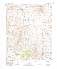
1953 Map of Gold Butte
USGS Topo · Published 1973About this map
Mica Peak and the Virgin Mountains dominate this 1953 landscape along the border of Nevada and Arizona, where the Mojave and Great Basin environments meet. The settlement of Gold Butte serves as a central point for the region's mining and ranching activity, evidenced by the numerous operations scattered through the surrounding ridges and basins. Prospectors and historians can trace the locations of the Lincoln Mine, Tramp Mine, and Snowflake Mine, while the southern portion of the map transitions into the Lake Mead National Recreational Area. The topography reflects a complex drainage system flowing toward Lake Mead, with prominent features like the geologic oddity of Devils Throat and the wide expanse of Grand Wash Bay illustrating the dramatic change in terrain as the mountains descend toward the reservoir’s edge.
Find a feature on this map
58 named features on this map. Tap any name to fly to it.
Don’t see what you’re looking for? This feature index may not catch every label — zoom into the map to look around manually.
Map Details
Editions of this 1953 Gold Butte Map
3 editions found
Other maps of this area

1886 · Saint Thomas
USGS Topo · 1:250,000

1886 · Mt. Trumbull
USGS Topo · 1:250,000

1892 · Mt. Trumbull
USGS Topo · 1:250,000

1893 · Saint Thomas
USGS Topo · 1:250,000

1926 · Bonelli
USGS Topo · 1:96,000

1953 · Overton Beach
USGS Topo · 1:62,500

1953 · Iceberg Canyon
USGS Topo · 1:62,500

1953 · Gold Butte
USGS Topo · 1:62,500

1953 · Virgin Basin
USGS Topo · 1:62,500

1953 · Grand Canyon
USGS Topo · 1:250,000