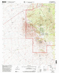
1999 Map of Gold Hill
USGS Topo · Published 2002About this map
Mining operations and remote ranching characterize this high-elevation landscape along the boundary of Hidalgo and Grant Counties. The terrain is dominated by significant peaks including Apache Mountain, Walker Mountain, and Round Mountain, with the Gila National Forest covering the eastern half of the quadrangle. A cluster of historic extraction sites, such as the Monarch Mine, Golden Cross Mine, and Ruby Mine, are concentrated near the headwaters of Monarch Canyon and Gold Hill. Evidence of the region's ranching heritage is visible through widely dispersed landmarks like Round Mountain Ranch, the W D Ranch, and numerous water sources such as Peterson Spring and Hoodoo Spring. The isolated Gold Hill Cemetery sits near the base of its namesake height, serving as a quiet witness to the generations of miners and ranchers who worked these canyons.
Find a feature on this map
51 named features on this map. Tap any name to fly to it.
Don’t see what you’re looking for? This feature index may not catch every label — zoom into the map to look around manually.
Map Details
Editions of this 1999 Gold Hill Map
This is the sole edition of this map. No revisions or reprints were ever made.
Other maps of this area

1909 · Silver City
USGS Topo · 1:125,000

1950 · Burro Peak
USGS Topo · 1:24,000

1951 · Big Burro Mountains
USGS Topo · 1:24,000

1954 · Silver City
USGS Topo · 1:250,000

1958 · Silver City
USGS Topo · 1:250,000

1959 · Redrock
USGS Topo · 1:62,500

1962 · Silver City
USGS Topo · 1:250,000

1962 · Ninetysix Ranch
USGS Topo · 1:24,000

1962 · Lisbon
USGS Topo · 1:24,000

1963 · Lordsburg
USGS Topo · 1:24,000