
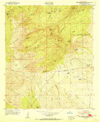
1951 Map of Big Burro Mountains
USGS Topo · Published 1951About this map
The Continental Divide cuts a diagonal path through this landscape, marking the high crest of the Big Burro Mountains within the Gila National Forest. This 1951 record identifies a significant mining history, though many operations like the Austin Amazon Mines and Red Hill Turquoise Mine are noted as inactive by the time of the mid-century field check. The concentration of workings, including the Merry Widow Shaft and Spar Hill Mine, suggests a previous era of intense extraction for turquoise, copper, and other minerals in the hills surrounding Burro Peak.
Find a feature on this map
41 named features on this map. Tap any name to fly to it.
Don’t see what you’re looking for? This feature index may not catch every label — zoom into the map to look around manually.
Map Details
Editions of this 1951 Big Burro Mountains Map
2 editions found
Other maps of this area

1909 · Silver City
USGS Topo · 1:125,000

1950 · Tyrone
USGS Topo · 1:24,000

1950 · White Signal
USGS Topo · 1:24,000

1950 · Wind Mountain
USGS Topo · 1:24,000

1950 · Burro Peak
USGS Topo · 1:24,000

1951 · White Signal
USGS Topo · 1:24,000
1951 · Tyrone
USGS Topo · 1:24,000

1951 · Wind Mountain
USGS Topo · 1:24,000

1954 · Silver City
USGS Topo · 1:250,000

1958 · Silver City
USGS Topo · 1:250,000