
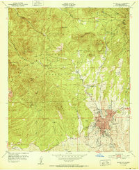
1951 Map of Wind Mountain
USGS Topo · Published 1951About this map
Little Burro Mountains and the Gila National Forest dominate this mid-century New Mexico landscape, which is marked by a deep history of mineral exploration and ranching. The presence of the Shrine Mine alongside names like the Blackhawk Mines, Burro Chief Mine, and Liberty Bell Mine underscores the region's mining industry at the time of the survey. An Indian Burial Ground near McCain Spring provides a rare recorded glimpse into the area's ancient history, while scattered family outposts such as Fleming Ranch, Woodward Ranch, and Kaufman Ranch illustrate the post-war ranching economy. The Continental Divide winds across the lower right corner, where the terrain drops sharply into deep drainage systems like California Gulch and Whitewater Canyon.
Find a feature on this map
54 named features on this map. Tap any name to fly to it.
Don’t see what you’re looking for? This feature index may not catch every label — zoom into the map to look around manually.
Map Details
Editions of this 1951 Wind Mountain Map
This is the sole edition of this map. No revisions or reprints were ever made.
Other maps of this area

1909 · Silver City
USGS Topo · 1:125,000

1949 · Circle Mesa
USGS Topo · 1:24,000

1950 · Tyrone
USGS Topo · 1:24,000

1950 · White Signal
USGS Topo · 1:24,000

1950 · Wind Mountain
USGS Topo · 1:24,000

1950 · Burro Peak
USGS Topo · 1:24,000

1950 · Silver City
USGS Topo · 1:24,000

1951 · Circle Mesa
USGS Topo · 1:24,000

1951 · White Signal
USGS Topo · 1:24,000
1951 · Silver City
USGS Topo · 1:24,000