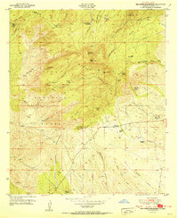
1951 Map of Burro Peak
USGS Topo · Published 1951About this map
The Big Burro Mountains define this mid-century landscape in Grant County, where the Continental Divide winds through high peaks like Burro Peak and Jacks Mtn. This survey captures a post-war mining district in transition, as numerous historical extraction sites are noted as inactive. Prospective researchers can locate the Red Hill Turquoise Mine, the Spar Hill Mine, and the Austin Amazon Mines, reflecting the region's rich mineral history. The land within the Gila National Forest is dotted with several family-held agricultural operations, including the Burro Mountain Homestead, Silsby Ranch, and McCauley Ranch. These homesteads and ranches, such as the Walking X Ranch, are connected by primitive roads and drainage systems like Arastre Gulch and Whitetail Canyon, illustrating the isolated character of Southwest New Mexican ranching life during this era.
Find a feature on this map
43 named features on this map. Tap any name to fly to it.
Don’t see what you’re looking for? This feature index may not catch every label — zoom into the map to look around manually.
Map Details
Editions of this 1951 Burro Peak Map
2 editions found
Other maps of this area

1909 · Silver City
USGS Topo · 1:125,000

1950 · Tyrone
USGS Topo · 1:24,000

1950 · White Signal
USGS Topo · 1:24,000

1950 · Wind Mountain
USGS Topo · 1:24,000

1950 · Burro Peak
USGS Topo · 1:24,000

1951 · White Signal
USGS Topo · 1:24,000

1951 · Big Burro Mountains
USGS Topo · 1:24,000
1951 · Tyrone
USGS Topo · 1:24,000

1951 · Wind Mountain
USGS Topo · 1:24,000

1954 · Silver City
USGS Topo · 1:250,000