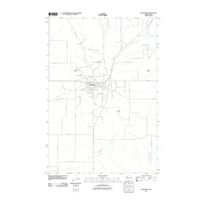
2011 Map of Goldendale
USGS Topo · Published 2011About this map
The city of Goldendale serves as the focal point of this 2011 survey, situated at a transition between the northern high ground and the drainage of the Little Klickitat River. The landscape is defined by its agricultural and scientific utility, most notably marked by the Goldendale Astronomical Observatory north of the town center. The transportation infrastructure reveals a mix of old and new, with the Burlington Northern line and Goldendale Airport supporting regional transit. Water resources are well-mapped, including Bloodgood Creek, which flows past the Klickitat County Fairgrounds, and Swale Creek to the south. Notable elevations such as Lorena Butte and Battle Butte rise above the surrounding fields, providing clear landmarks for the various rural routes like Hanging Rock Rd and Pipeline Rd that crisscross the quadrangle.
Find a feature on this map
69 named features on this map. Tap any name to fly to it.
Don’t see what you’re looking for? This feature index may not catch every label — zoom into the map to look around manually.
Map Details
Editions of this 2011 Goldendale Map
This is the sole edition of this map. No revisions or reprints were ever made.
Other maps of this area

1953 · The Dalles
USGS Topo · 1:250,000

1956 · The Dalles
USGS Topo · 1:250,000

1957 · The Dalles
USGS Topo · 1:250,000

1957 · Wasco
USGS Topo · 1:62,500

1957 · Goldendale
USGS Topo · 1:62,500

1957 · Wishram
USGS Topo · 1:62,500

1957 · Satus Pass
USGS Topo · 1:62,500

1971 · Rufus
USGS Topo · 1:24,000
1977 · Wishram
USGS Topo · 1:24,000
1977 · Biggs Junction
USGS Topo · 1:24,000