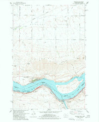
1977 Map of Wishram
USGS Topo · Published 1977About this map
Columbia River Lake Celilo dominates this landscape where the high desert meets the river's edge, serving as a critical corridor for both the Burlington Northern and Union Pacific railroads. The settlement of Wishram sits as a vital rail hub on the Washington side, while Celilo Village and the Deschutes River confluence mark the Oregon shore. This survey captures the infrastructure of the mid-1970s, from the Substation at Wishram Heights to the navigational aids like the Celilo Light and various gaging stations along the water.
Find a feature on this map
49 named features on this map. Tap any name to fly to it.
Don’t see what you’re looking for? This feature index may not catch every label — zoom into the map to look around manually.
Map Details
Editions of this 1977 Wishram Map
This is the sole edition of this map. No revisions or reprints were ever made.
Other maps of this area

1934 · The Dalles
USGS Topo · 1:125,000

1953 · The Dalles
USGS Topo · 1:250,000

1956 · The Dalles
USGS Topo · 1:250,000

1957 · The Dalles
USGS Topo · 1:250,000

1957 · Klickitat
USGS Topo · 1:62,500

1957 · Goldendale
USGS Topo · 1:62,500

1957 · The Dalles
USGS Topo · 1:62,500

1957 · Wishram
USGS Topo · 1:62,500

1974 · Stacker Butte
USGS Topo · 1:24,000
1974 · Locust Grove
USGS Topo · 1:24,000