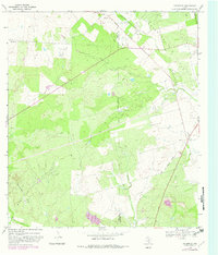
1968 Map of Goldfinch
USGS Topo · Published 1982About this map
Goldfinch and the surrounding South Texas brush country appear here during a period of active petroleum development along the border of Frio and Atascosa counties. The landscape is defined by the extensive Charlotte Oil Field and West Charlotte Oil Field, where numerous well sites dot the terrain between the Marshall Hills and Chiltipin Creek. While the presence of an Old Railroad Grade and the Luna Cem point to the area's earlier agricultural and transit history, the 1980s-era revisions highlight evolving infrastructure like the Landing Strip near the northern boundary. Small settlements like Davis remain connected by a network of light-duty roads, while the natural drainage of West Clear Creek and Liveoak Creek continues to shape the low-lying sections of this rural energy-producing corridor.
Find a feature on this map
17 named features on this map. Tap any name to fly to it.
Don’t see what you’re looking for? This feature index may not catch every label — zoom into the map to look around manually.
Map Details
Editions of this 1968 Goldfinch Map
2 editions found
Other maps of this area

1934 · Schattel
USGS Topo · 1:62,500

1953 · Crystal City
USGS Topo · 1:250,000

1955 · Crystal City
USGS Topo · 1:250,000

1956 · Jourdanton
USGS Topo · 1:62,500

1956 · Hindes
USGS Topo · 1:62,500

1956 · Franklin Settlement
USGS Topo · 1:62,500

1961 · Crystal City
USGS Topo · 1:250,000

1968 · Crystal City
USGS Topo · 1:250,000
1968 · Dobrowolski
USGS Topo · 1:24,000
1968 · Schattel
USGS Topo · 1:24,000