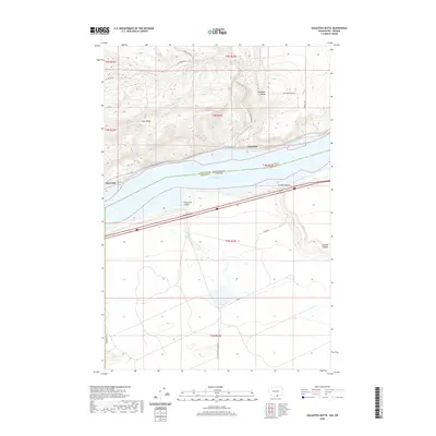
2020 Map of Golgotha Butte
USGS Topo · Published 2020About this map
Lake Umatilla dominates the center of this landscape, marking the watery border between Washington's Klickitat County and Oregon's Morrow County. The northern shore is defined by the steep rises of Alder Ridge and the prominent Golgotha Butte, where small settlements like Alderdale and McCredie once established footholds along the river's path. Numerous drainages such as Sixprong Cr and Cottonwood Cr carve through the northern hills, while Sally Spring provides a rare named water source in the higher elevations. On the southern Oregon side, the terrain transitions into the deep cuts of Threemile Canyon and Sixmile Canyon. This map captures a modern view of a region historically shaped by the Columbia River's flow and the development of transportation corridors on both banks.
Find a feature on this map
26 named features on this map. Tap any name to fly to it.
Don’t see what you’re looking for? This feature index may not catch every label — zoom into the map to look around manually.
Map Details
Editions of this 2020 Golgotha Butte Map
This is the sole edition of this map. No revisions or reprints were ever made.
Other maps of this area

1906 · Blalock Island
USGS Topo · 1:125,000

1908 · Blalock Island
USGS Topo · 1:125,000

1916 · Arlington
USGS Topo · 1:125,000

1953 · Pendleton
USGS Topo · 1:250,000

1953 · The Dalles
USGS Topo · 1:250,000

1956 · The Dalles
USGS Topo · 1:250,000

1956 · Pendleton
USGS Topo · 1:250,000

1957 · The Dalles
USGS Topo · 1:250,000
1962 · Phinny Hill
USGS Topo · 1:24,000

1962 · Canoe Ridge
USGS Topo · 1:24,000