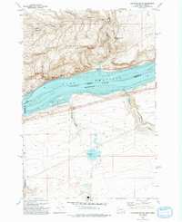
1993 Map of Golgotha Butte
USGS Topo · Published 1993About this map
Lake Umatilla and the Columbia River serve as the central corridor of this landscape, marking the interstate border between Washington and Oregon. The northern side is dominated by the steep rises of Sand Ridge and Alder Ridge, where the settlement of Sixprong sits near the headwaters of Sixprong Creek. In the rugged hills above the river, Golgotha Butte stands near a Radio Tower and Sally Spring, overlooking a series of complex 4WD road networks used for utility access. On the Oregon shore, the terrain shifts into a more industrial and agricultural pattern. Large Settling Ponds and a Feedlot are situated south of the river, while natural features like Threemile Canyon and Sixmile Canyon cut through the benchland. Evidence of local transport and industry is visible in the McCredie area and a riverside Boat Ramp.
Find a feature on this map
23 named features on this map. Tap any name to fly to it.
Don’t see what you’re looking for? This feature index may not catch every label — zoom into the map to look around manually.
Map Details
Editions of this 1993 Golgotha Butte Map
This is the sole edition of this map. No revisions or reprints were ever made.
Other maps of this area

1906 · Blalock Island
USGS Topo · 1:125,000

1908 · Blalock Island
USGS Topo · 1:125,000

1916 · Arlington
USGS Topo · 1:125,000

1953 · Pendleton
USGS Topo · 1:250,000

1953 · The Dalles
USGS Topo · 1:250,000

1956 · The Dalles
USGS Topo · 1:250,000

1956 · Pendleton
USGS Topo · 1:250,000

1957 · The Dalles
USGS Topo · 1:250,000
1962 · Phinny Hill
USGS Topo · 1:24,000

1962 · Canoe Ridge
USGS Topo · 1:24,000