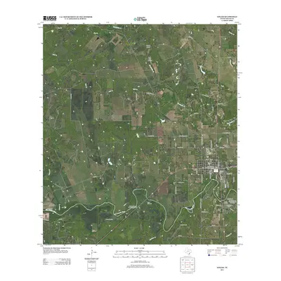
2013 Map of Goliad
USGS Topo · Published 2013About this map
Goliad serves as the focal point of this South Texas landscape, where the San Antonio River winds past several of the state’s most significant colonial sites. The map clearly identifies the Goliad County Courthouse Historic District at the town center, while providing detailed locations for the Mission Nuestra Senora del Rosario to the west and the Presidio La Bahia and Presidio Nuestra Senora de Loreto de la Bahia to the south. This concentration of Spanish colonial and early Texas Republic landmarks illustrates the strategic importance of this river crossing. Beyond the town, the terrain is defined by drainages like Manahuilla Cr and Cabeza Cr, punctuated by ranching infrastructure such as the Farley Windmill and Matt Windmill. Several local cemeteries, including Glendale Cem and Wisbey Cem, are noted throughout the surrounding rural landscape.
Find a feature on this map
70 named features on this map. Tap any name to fly to it.
Don’t see what you’re looking for? This feature index may not catch every label — zoom into the map to look around manually.
Map Details
Editions of this 2013 Goliad Map
This is the sole edition of this map. No revisions or reprints were ever made.
Other maps of this area

1953 · Beeville
USGS Topo · 1:250,000

1956 · Beeville
USGS Topo · 1:250,000

1960 · Beeville
USGS Topo · 1:250,000

1962 · Live Oak Lake
USGS Topo · 1:24,000

1962 · Melo
USGS Topo · 1:24,000

1962 · Hensley Lake
USGS Topo · 1:24,000

1962 · Goliad
USGS Topo · 1:24,000

1963 · Weesatche
USGS Topo · 1:24,000

1963 · Berclair
USGS Topo · 1:24,000
1963 · Runge SE
USGS Topo · 1:24,000