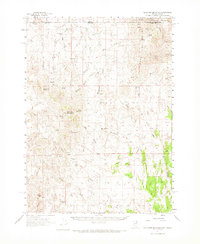
1961 Map of Gollaher Mountain
USGS Topo · Published 1974About this map
Gollaher Mountain dominates the center of this high-desert landscape in northern Elko County, situated just south of the Idaho-Nevada border. This 1961 survey documents a remote portion of the Sawtooth National Forest defined by a dense network of seasonal springs and named draws. To the north, Dead Line Ridge separates the high country from Hot Springs and Coon Creek. The map is particularly notable for its record of early 20th-century water sources and landmarks used by ranchers and hunters, including several with family names like Indian Mike Spring, Elrod Spring, and Crockett Spring. The absence of developed roads, replaced instead by numerous jeep trails, emphasizes the isolated character of this region before modern infrastructure. Notable terrain features such as Tepee Rock and the steep Devils Pass serve as key navigational points within the complex drainages of Mustang Draw and Boulder Draw.
Find a feature on this map
51 named features on this map. Tap any name to fly to it.
Don’t see what you’re looking for? This feature index may not catch every label — zoom into the map to look around manually.
Map Details
Editions of this 1961 Gollaher Mountain Map
2 editions found
Other maps of this area

1955 · Twin Falls
USGS Topo · 1:250,000

1955 · Wells
USGS Topo · 1:250,000

1957 · Delaplain
USGS Topo · 1:62,500

1958 · Wells
USGS Topo · 1:250,000

1958 · Twin Falls
USGS Topo · 1:250,000

1961 · Wells
USGS Topo · 1:250,000

1961 · Delano Mountains
USGS Topo · 1:62,500

1961 · Gollaher Mountain
USGS Topo · 1:62,500

1961 · Goose Creek
USGS Topo · 1:62,500

1961 · Dairy Valley
USGS Topo · 1:62,500