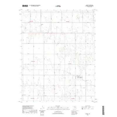
2018 Map of Goltry
USGS Topo · Published 2018About this map
Goltry occupies the southeastern corner of this Oklahoma landscape, defined by a rigid grid of rural roads and the drainage of several local waterways. The township layout, structured by the Public Land Survey System including t24n r9w and t25n r10w, reveals a landscape of dispersed agricultural activity. Several local burial grounds, including Timberlake Cem, Karoma Cem, and Good Hope Cem, are scattered across the quadrangle, providing critical points of reference for genealogical research and local history. Water courses such as Turkey Cr, Twin Spring Cr, and Wagon Cr meander through the sections, often intersecting with the alphabetized and numbered road network. The town of Goltry itself maintains its core near the intersection of Newell Ave and numbered streets, where a Po serves as a central landmark for the community.
Find a feature on this map
42 named features on this map. Tap any name to fly to it.
Don’t see what you’re looking for? This feature index may not catch every label — zoom into the map to look around manually.
Map Details
Editions of this 2018 Goltry Map
This is the sole edition of this map. No revisions or reprints were ever made.
Other maps of this area
1955 · Woodward
USGS Topo · 1:250,000
1956 · Ringwood
USGS Topo · 1:62,500
1958 · Woodward
USGS Topo · 1:250,000
1969 · Jet
USGS Topo · 1:24,000
1969 · Goltry
USGS Topo · 1:24,000
1969 · Fairview NE
USGS Topo · 1:24,000
1969 · Nash
USGS Topo · 1:24,000
1969 · Helena
USGS Topo · 1:24,000
1969 · Jet SE
USGS Topo · 1:24,000
1969 · Cherokee South
USGS Topo · 1:24,000