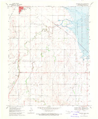
1969 Map of Cherokee South
USGS Topo · Published 1971About this map
The town of Cherokee anchors this survey at the intersection of the Atchison Topeka and Santa Fe railroad and major highways. The landscape transitions from the developed town grid, featuring a Hospital, Radio Tower, and the Cherokee Cem, into the vast saline flats of the Salt Plains National Wildlife Refuge to the east. The drainage pattern is defined by the winding paths of Clay Creek, West Clay Creek, and East Clay Creek, which cut through the townships of Lincoln and Clay. This 1969 perspective shows a rural Oklahoma economy balanced between transportation infrastructure, small-town utilities like the Sewage Disposal Ponds, and natural preservation. A Roadside Park along Highway 64 offers a small recreational point in a landscape otherwise dominated by section lines and meandering creek beds.
Find a feature on this map
23 named features on this map. Tap any name to fly to it.
Don’t see what you’re looking for? This feature index may not catch every label — zoom into the map to look around manually.
Map Details
Editions of this 1969 Cherokee South Map
This is the sole edition of this map. No revisions or reprints were ever made.
Other maps of this area

1955 · Woodward
USGS Topo · 1:250,000

1958 · Woodward
USGS Topo · 1:250,000

1968 · Carmen
USGS Topo · 1:24,000

1969 · Jet
USGS Topo · 1:24,000

1969 · Goltry
USGS Topo · 1:24,000

1969 · Lambert
USGS Topo · 1:24,000

1969 · Helena
USGS Topo · 1:24,000

1969 · Manchester SW
USGS Topo · 1:24,000

1969 · Cherokee North
USGS Topo · 1:24,000

1969 · Ingersoll
USGS Topo · 1:24,000