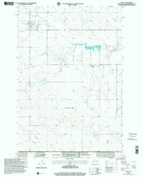
1997 Map of Golva
USGS Topo · Published 2001About this map
Golva serves as the primary hub in this corner of Golden Valley County, where the grid of the High Plains meets the dramatic draws and plateaus of the Badlands. The landscape is defined by the winding course of Bullion Creek and the expansive Little Missouri National Grassland, which dominates the southern portion of the sheet. Local infrastructure is sparse but critical, evidenced by Landing Strips and several Gravel Pits used for rural road maintenance. Genealogy interests are supported by the inclusion of Saint Marys Cem near the town center and the more isolated Burkey Cem further south. The map documents a transition from the agricultural tablelands of Lone Tree to the breaks near the Ninth Standard Parallel North, revealing the intersection of early ranching territory and federal land management. To the southeast, the small settlement of Alpha sits near the headwaters of Williams Creek, illustrating the scattered nature of community life in the late twentieth-century North Dakota interior.
Find a feature on this map
19 named features on this map. Tap any name to fly to it.
Don’t see what you’re looking for? This feature index may not catch every label — zoom into the map to look around manually.
Map Details
Editions of this 1997 Golva Map
This is the sole edition of this map. No revisions or reprints were ever made.
Other maps of this area

1953 · Miles City
USGS Topo · 1:250,000

1953 · Dickinson
USGS Topo · 1:250,000

1957 · Dickinson
USGS Topo · 1:250,000

1957 · Miles City
USGS Topo · 1:250,000

1958 · Miles City
USGS Topo · 1:250,000

1979 · Sentinel Butte SE
USGS Topo · 1:24,000

1979 · Three V Crossing
USGS Topo · 1:24,000

1980 · Golva
USGS Topo · 1:24,000

1980 · Thelan
USGS Topo · 1:24,000

1980 · Alpha
USGS Topo · 1:24,000