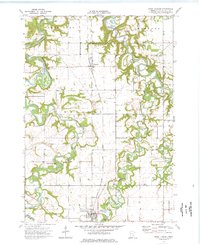
1974 Map of Good Thunder
USGS Topo · Published 1976About this map
The confluence of the Blue Earth River and its tributaries dominates this mid-1970s survey of southern Minnesota. The settlement of Good Thunder anchors the southern edge of the map, while Rapidan is situated to the north, near the Chicago Milwaukee St Paul and Pacific rail line. The landscape is defined by the winding paths of the Le Sueur River, Maple River, and Cobb River, which carve deep, wooded valleys through the surrounding agricultural townships of South Bend and Lyra.
Find a feature on this map
25 named features on this map. Tap any name to fly to it.
Don’t see what you’re looking for? This feature index may not catch every label — zoom into the map to look around manually.
Map Details
Editions of this 1974 Good Thunder Map
This is the sole edition of this map. No revisions or reprints were ever made.
Other maps of this area

1950 · Mankato East
USGS Topo · 1:62,500

1951 · Mankato East
USGS Topo · 1:62,500

1951 · Mankato West
USGS Topo · 1:62,500

1953 · Saint Paul
USGS Topo · 1:250,000

1953 · New Ulm
USGS Topo · 1:250,000

1954 · Fairmont
USGS Topo · 1:250,000

1954 · Mason City
USGS Topo · 1:250,000

1957 · New Ulm
USGS Topo · 1:250,000

1957 · Mason City
USGS Topo · 1:250,000

1958 · New Ulm
USGS Topo · 1:250,000