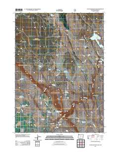
2011 Map of Goodlow Mountain
USGS Topo · Published 2011About this map
The Haynesville settlement and its nearby Haynesville Cemetery anchor this portion of Klamath County, characterized by a complex network of water management and high-desert ranching. The landscape is defined by massive water storage and diversion projects, most notably the Gerber Reservoir and its associated Gerber Dam, along with the Big Adobe Reservoir and Randall Reservoir. These reservoirs, fed by drainages like Miller Creek and Dobe Creek, support a series of family-named agricultural holdings including Bieler Ranch, Noble Ranch, and Pankey Ranch. The terrain transitions from the volcanic heights of Goodlow Mountain and Goodlow Rim down to the broad expanses of Lockey Flat and the Pankey Basin. This map captures a modern snapshot of the region's long-standing reliance on the North Canal and diversion dams to sustain rural life and livestock in the Oregon interior.
Find a feature on this map
45 named features on this map. Tap any name to fly to it.
Don’t see what you’re looking for? This feature index may not catch every label — zoom into the map to look around manually.
Map Details
Editions of this 2011 Goodlow Mountain Map
This is the sole edition of this map. No revisions or reprints were ever made.
Other maps of this area
1889 · Klamath
USGS Topo · 1:250,000
1894 · Klamath
USGS Topo · 1:250,000
1955 · Klamath Falls
USGS Topo · 1:250,000
1957 · Malin
USGS Topo · 1:62,500
1958 · Klamath Falls
USGS Topo · 1:250,000
1960 · Gerber Reservoir
USGS Topo · 1:62,500
1960 · Bly
USGS Topo · 1:62,500
1960 · Beatty
USGS Topo · 1:62,500
1988 · Bryant Mountain
USGS Topo · 1:24,000
1988 · Gerber Reservoir
USGS Topo · 1:24,000