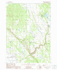
1988 Map of Goodlow Mountain
USGS Topo · Published 1988About this map
Haynesville and the southern reaches of the Fremont National Forest dominate this high-desert landscape in the late 1980s. The map reveals a complex water management system essential for ranching and forestry, characterized by numerous developed springs and man-made impoundments like Gerber Reservoir and Noble Reservoir. The presence of Pankey Lake, De Vaul Lake, and several reservoirs alongside the Pankey Basin suggests a geography shaped by seasonal runoff and systematic irrigation. Local industry and infrastructure are noted through the inclusion of a Gaging Station, a Hellport, and a Cinder Pit near Goodlow Mountain. Genealogical interest is found at a lone cemetery near the road south of Haynesville, while historical land use is marked by features such as Wilkerson Horse-Camp and family-named landmarks like Gillette Spring and Tillie Spring.
Find a feature on this map
60 named features on this map. Tap any name to fly to it.
Don’t see what you’re looking for? This feature index may not catch every label — zoom into the map to look around manually.
Map Details
Editions of this 1988 Goodlow Mountain Map
This is the sole edition of this map. No revisions or reprints were ever made.
Other maps of this area

1889 · Klamath
USGS Topo · 1:250,000

1894 · Klamath
USGS Topo · 1:250,000

1955 · Klamath Falls
USGS Topo · 1:250,000

1957 · Malin
USGS Topo · 1:62,500

1958 · Klamath Falls
USGS Topo · 1:250,000

1960 · Gerber Reservoir
USGS Topo · 1:62,500

1960 · Bly
USGS Topo · 1:62,500

1960 · Beatty
USGS Topo · 1:62,500
1988 · Bryant Mountain
USGS Topo · 1:24,000
1988 · Gerber Reservoir
USGS Topo · 1:24,000