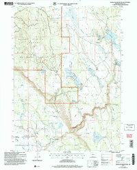
2004 Map of Goodlow Mountain
USGS Topo · Published 2007About this map
Langell Valley and the surrounding high prairie dominate this survey, capturing a landscape defined by ranching and water management in the early 2000s. The small settlement of Haynesville sits at the valley floor near a local Cem, while the higher elevations of Goodlow Mountain are managed as part of the Fremont National Forest. The map documents an extensive network of artificial water storage and irrigation infrastructure, including the large Gerber Reservoir, Noble Reservoir, and the Miller Diversion Dam.
Find a feature on this map
52 named features on this map. Tap any name to fly to it.
Don’t see what you’re looking for? This feature index may not catch every label — zoom into the map to look around manually.
Map Details
Editions of this 2004 Goodlow Mountain Map
This is the sole edition of this map. No revisions or reprints were ever made.
Other maps of this area

1889 · Klamath
USGS Topo · 1:250,000

1894 · Klamath
USGS Topo · 1:250,000

1955 · Klamath Falls
USGS Topo · 1:250,000

1957 · Malin
USGS Topo · 1:62,500

1958 · Klamath Falls
USGS Topo · 1:250,000

1960 · Gerber Reservoir
USGS Topo · 1:62,500

1960 · Bly
USGS Topo · 1:62,500

1960 · Beatty
USGS Topo · 1:62,500
1988 · Bryant Mountain
USGS Topo · 1:24,000
1988 · Gerber Reservoir
USGS Topo · 1:24,000