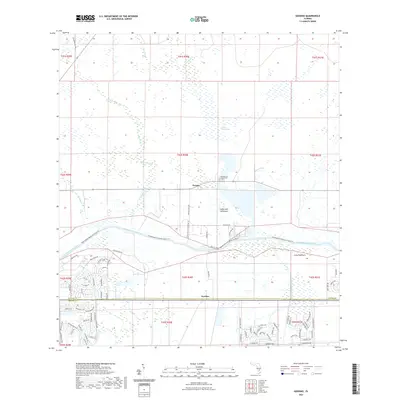
2021 Map of Goodno
USGS Topo · Published 2021About this map
The Caloosahatchee River and the Caloosahatchee Canal dominate this landscape, serving as critical conduits between the Gulf and the interior wetlands. The settlement of Ortona sits just north of the waterway, while Goodno is situated further south along the Glades and Hendry county line. This geography is defined by its transition from open water to dense subtropical terrain, featuring notable natural landmarks like Coffee Mill Hammock, Long Hammock, and the expansive Linden Pens Marsh. This 2021 survey documents the persistent rural character of the region, where numerous named branches like York Branch, Turkey Branch, and Cypress Branch feed into the larger water systems. To the west, a dense network of suburban residential streets, including Birchwood Dr and Winchester Ave, highlights the modern growth pushing into these traditionally agricultural and marshland areas, while the Ortona Cem remains a localized point of historical significance.
Find a feature on this map
87 named features on this map. Tap any name to fly to it.
Don’t see what you’re looking for? This feature index may not catch every label — zoom into the map to look around manually.
Map Details
Editions of this 2021 Goodno Map
This is the sole edition of this map. No revisions or reprints were ever made.
Other maps of this area

1956 · West Palm Beach
USGS Topo · 1:250,000

1957 · West Palm Beach
USGS Topo · 1:250,000

1958 · West Palm Beach
USGS Topo · 1:250,000

1958 · La Belle NW
USGS Topo · 1:24,000

1958 · Goodno
USGS Topo · 1:24,000

1958 · Felda NE
USGS Topo · 1:24,000

1958 · Sears
USGS Topo · 1:24,000
1958 · La Belle
USGS Topo · 1:24,000
1958 · Palmdale
USGS Topo · 1:24,000
1970 · Lakeport
USGS Topo · 1:24,000