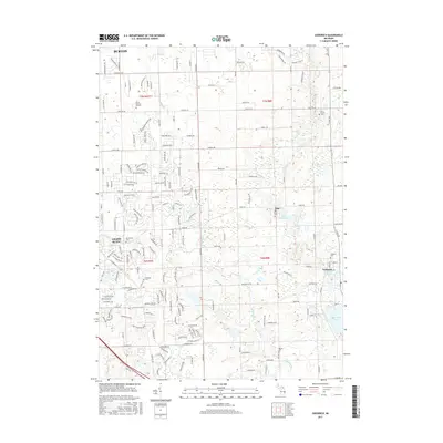
2017 Map of Goodrich
USGS Topo · Published 2017About this map
The village of Goodrich and the community of Atlas anchor this 2017 survey of Genesee County, showing a landscape defined by its glacial hydrology and early mill sites. The Goodrich Millpond and Atlas Millpond remain central to their respective settlements, while Thread Cr and Kearsley Cr wind through the township. For genealogists, the map is particularly dense with burial grounds, ranging from larger sites like Peace Memory Gardens in Burton to smaller local landmarks such as Goodrich Cem, Oakwood Cem, and the Horton Cem further south. The transition from the urban edges of Grand Blanc to the more open areas around Shipanguag Lake and Gale Lake illustrates the evolving suburban and rural character of the region. Distinctive natural features like Smith Lake and Cummings Lake are interspersed with a modern road network that follows the original township grid lines of t6n r8e and t7n r8e.
Find a feature on this map
183 named features on this map. Tap any name to fly to it.
Don’t see what you’re looking for? This feature index may not catch every label — zoom into the map to look around manually.
Map Details
Editions of this 2017 Goodrich Map
This is the sole edition of this map. No revisions or reprints were ever made.
Other maps of this area

1920 · Flint
USGS Topo · 1:62,500

1920 · Holly
USGS Topo · 1:62,500

1922 · Holly
USGS Topo · 1:62,500

1922 · Flint
USGS Topo · 1:62,500

1943 · Holly
USGS Topo · 1:62,500

1943 · Flint
USGS Topo · 1:62,500

1943 · Ortonville
USGS Topo · 1:24,000
1945 · Ortonville
USGS Topo · 1:24,000

1945 · Hadley
USGS Topo · 1:24,000
1945 · Davisburg
USGS Topo · 1:24,000