
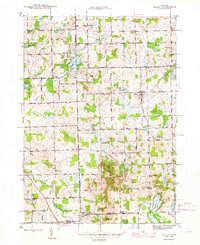
1945 Map of Hadley
USGS Topo · Published 1945About this map
Glacial lakes and small-town Michigan life define this 1940s landscape where the borders of Lapeer, Genesee, and Oakland counties meet. The village of Hadley serves as the primary hub, surrounded by a dense network of local district schools like Winn Sch and Cobb Sch that once anchored these rural neighborhoods. The terrain is marked by a complex system of kettle lakes and wetlands, ranging from the large Big Fish Lake in the south to Hasler Lake in the north, providing a clear picture of the region's hydrography before modern drainage and development altered many shorelines.
Find a feature on this map
64 named features on this map. Tap any name to fly to it.
Don’t see what you’re looking for? This feature index may not catch every label — zoom into the map to look around manually.
Map Details
Editions of this 1945 Hadley Map
2 editions found
Other maps of this area

1920 · Flint
USGS Topo · 1:62,500

1920 · Holly
USGS Topo · 1:62,500

1922 · Holly
USGS Topo · 1:62,500

1922 · Flint
USGS Topo · 1:62,500

1943 · Holly
USGS Topo · 1:62,500

1943 · Flint
USGS Topo · 1:62,500

1943 · Ortonville
USGS Topo · 1:24,000

1943 · Oxford
USGS Topo · 1:24,000

1943 · Metamora
USGS Topo · 1:24,000

1945 · Oxford
USGS Topo · 1:24,000