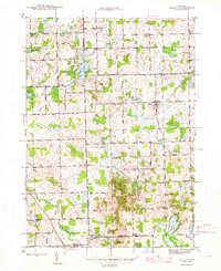
1945 Map of Hadley
USGS Topo · Published 1945About this map
Hadley serves as the central hub of this mid-1940s landscape, situated where the glacial topography of Lapeer County creates a dense network of kettle lakes and wetlands. The settlement pattern is defined by a traditional grid of rural schoolhouses and churches, including South Hadley Ch and a collection of family-named institutions like Kerr Sch, Merwin Sch, and Kipp Sch. These sites, along with Green Corners Cem, provide essential anchor points for genealogists tracing early twentieth-century residents.
Find a feature on this map
64 named features on this map. Tap any name to fly to it.
Don’t see what you’re looking for? This feature index may not catch every label — zoom into the map to look around manually.
Map Details
Editions of this 1945 Hadley Map
2 editions found

Other maps of this area

1920 · Flint
USGS Topo · 1:62,500

1920 · Holly
USGS Topo · 1:62,500

1922 · Holly
USGS Topo · 1:62,500

1922 · Flint
USGS Topo · 1:62,500

1943 · Holly
USGS Topo · 1:62,500

1943 · Flint
USGS Topo · 1:62,500

1943 · Ortonville
USGS Topo · 1:24,000

1943 · Oxford
USGS Topo · 1:24,000

1943 · Metamora
USGS Topo · 1:24,000

1945 · Oxford
USGS Topo · 1:24,000