
1943 Map of Oxford
USGS Topo · Published 1960About this map
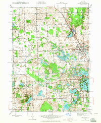
The Michigan Central railroad cuts a diagonal path through this landscape, anchoring the village of Oxford during the early 1940s. The region is defined by a dense cluster of glacial lakes, including Stony Lake, Lake Orion, and Long Lake, which by this era were already being integrated into recreational and residential patterns. Evidence of a well-distributed rural community is clear through the numerous local schools such as Prospect Sch, Block Sch, and Webber Sch, alongside the Seymour Lake Ch and Oakwood Cem in the north. The presence of the Indianwood Golf Course and the Agawam Scout Camp suggests the area's transition toward a leisure destination for nearby urban centers. The intricate network of township roads, including Oakwood Rd and Lapeer Rd, connects these scattered settlements and water bodies across Brandon and Oxford townships.
Find a feature on this map
80 named features on this map. Tap any name to fly to it.
Don’t see what you’re looking for? This feature index may not catch every label — zoom into the map to look around manually.
Map Details
Editions of this 1943 Oxford Map
2 editions found
Other maps of this area

1907 · Pontiac
USGS Topo · 1:62,500

1908 · Rochester
USGS Topo · 1:62,500

1936 · Clarkston
USGS Topo · 1:31,680

1936 · Rochester
USGS Topo · 1:31,680

1936 · Pontiac North
USGS Topo · 1:31,680

1943 · Clarkston
USGS Topo · 1:24,000

1943 · Pontiac North
USGS Topo · 1:24,000

1943 · Ortonville
USGS Topo · 1:24,000

1943 · Lake Orion
USGS Topo · 1:24,000

1943 · Metamora
USGS Topo · 1:24,000
Featured Places
- Orion Charter Township, MI
- Independence Charter Township, MI
- Oxford Charter Township, MI
- Oxford, MI
- Lake Orion, MI