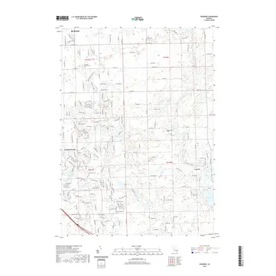
2019 Map of Goodrich
USGS Topo · Published 2019About this map
Shinanguag Lake and the winding Thread Cr define the hydrological character of this southeastern Genesee County landscape. In the village of Goodrich, the local street grid is established around Gale Lake and near the historic Oakwood Cem. To the north, the settlement of Atlas sits along the creek, while the northern margins of the map reach into the suburban expansion of Burton. Genealogists will find several burial grounds across the townships, including Lovedale Memorial Cem in the north and the Horton Cem near the southern border. The transition from the more developed residential areas of Grand Blanc to the open water and drainage systems of Bush Cr and Kearsley Cr illustrates the area's mix of community growth and natural wetlands.
Find a feature on this map
185 named features on this map. Tap any name to fly to it.
Don’t see what you’re looking for? This feature index may not catch every label — zoom into the map to look around manually.
Map Details
Editions of this 2019 Goodrich Map
This is the sole edition of this map. No revisions or reprints were ever made.
Other maps of this area

1920 · Flint
USGS Topo · 1:62,500

1920 · Holly
USGS Topo · 1:62,500

1922 · Holly
USGS Topo · 1:62,500

1922 · Flint
USGS Topo · 1:62,500

1943 · Holly
USGS Topo · 1:62,500

1943 · Flint
USGS Topo · 1:62,500

1943 · Ortonville
USGS Topo · 1:24,000
1945 · Ortonville
USGS Topo · 1:24,000

1945 · Hadley
USGS Topo · 1:24,000
1945 · Davisburg
USGS Topo · 1:24,000