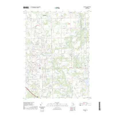
2023 Map of Goodrich
USGS Topo · Published 2023About this map
Goodrich and the surrounding township of Atlas define this landscape on the edge of the Flint metropolitan area. The terrain is characterized by a complex network of waterways, including Thread Creek and Kearsley Creek, which flow through a mix of established residential subdivisions and open land. For those researching family history, the map identifies several critical burial grounds, such as the Pine Grove Historical Cem and the Lovedale Memorial Cem in the north near Burton. The southeastern portion of the quadrangle is notably more lacustrine, dominated by Shinanguag Lake and Gale Lake. The transition from the more densely plotted streets of Grand Blanc in the west to the open spaces near Cummings Lake illustrates the continuing expansion of southern Genesee County.
Find a feature on this map
187 named features on this map. Tap any name to fly to it.
Don’t see what you’re looking for? This feature index may not catch every label — zoom into the map to look around manually.
Map Details
Editions of this 2023 Goodrich Map
This is the sole edition of this map. No revisions or reprints were ever made.
Other maps of this area

1920 · Flint
USGS Topo · 1:62,500

1920 · Holly
USGS Topo · 1:62,500

1922 · Holly
USGS Topo · 1:62,500

1922 · Flint
USGS Topo · 1:62,500

1943 · Holly
USGS Topo · 1:62,500

1943 · Flint
USGS Topo · 1:62,500

1943 · Ortonville
USGS Topo · 1:24,000
1945 · Ortonville
USGS Topo · 1:24,000

1945 · Hadley
USGS Topo · 1:24,000
1945 · Davisburg
USGS Topo · 1:24,000