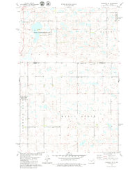
1978 Map of Goodrich SW
USGS Topo · Published 1979About this map
Sperry Lake and a series of smaller prairie potholes dot the landscape along the county line between Sheridan and Burleigh Counties. This 1970s survey documents a region defined by its conservation areas, specifically the National Waterfowl Production Area which spans much of the northern and western sections of the quadrangle. The terrain transitions into the named areas of Mauch, Hazel Grove, and the basin surrounding Lake Florence. Human impact is visible through a network of section-line roads and scattered infrastructure, including several wells and a Gravel Pit. The map captures the specialized agricultural and conservation character of the Missouri Coteau region before late-century shifts in land management.
Find a feature on this map
9 named features on this map. Tap any name to fly to it.
Don’t see what you’re looking for? This feature index may not catch every label — zoom into the map to look around manually.
Map Details
Editions of this 1978 Goodrich SW Map
This is the sole edition of this map. No revisions or reprints were ever made.
Other maps of this area

1954 · McClusky
USGS Topo · 1:250,000

1958 · McClusky
USGS Topo · 1:250,000

1960 · Florence Lake
USGS Topo · 1:24,000

1960 · Denhoff
USGS Topo · 1:24,000
1978 · Goodrich East
USGS Topo · 1:24,000
1978 · Goodrich West
USGS Topo · 1:24,000
1978 · Woodhouse Lake
USGS Topo · 1:24,000
1979 · Wing
USGS Topo · 1:24,000
1979 · Lake Helen
USGS Topo · 1:24,000
1979 · Arena
USGS Topo · 1:24,000