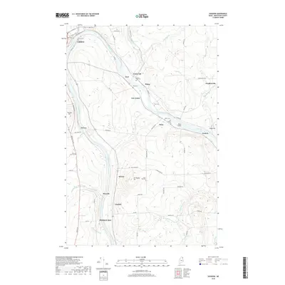
2018 Map of Goodwin
USGS Topo · Published 2018About this map
The Aroostook River winds through this northern Maine landscape, anchoring a network of small settlements and agricultural sidings between Caribou and Presque Isle. The importance of the railroad in this potato-farming region is evidenced by infrastructure like Dow Siding RD and Main Siding RD, connecting remote hamlets to the larger trade network. Smaller communities such as Grimes Mill, East Lyndon, and Houghtonville are documented alongside numerous family and community burial grounds, including the Old Catholic Cem and Grimes Kelly Cem. The terrain is punctuated by named rises like Old Higgins Hill and Prestile Hill, while several brooks, such as Little Madawaska River and Nichols Brook, feed the central river valley. This survey provides a clear view of the rural road network, from Van Buren RD to Green Ridge RD, that has long defined the social and economic geography of Aroostook County.
Find a feature on this map
70 named features on this map. Tap any name to fly to it.
Don’t see what you’re looking for? This feature index may not catch every label — zoom into the map to look around manually.
Map Details
Editions of this 2018 Goodwin Map
This is the sole edition of this map. No revisions or reprints were ever made.
Other maps of this area

1929 · Caribou
USGS Topo · 1:48,000

1930 · Fort Fairfield
USGS Topo · 1:48,000

1932 · Caribou
USGS Topo · 1:62,500

1933 · Fort Fairfield
USGS Topo · 1:62,500

1935 · Presque Isle
USGS Topo · 1:62,500

1936 · Mars Hill
USGS Topo · 1:48,000

1940 · Mars Hill
USGS Topo · 1:62,500

1951 · Mars Hill
USGS Topo · 1:62,500

1951 · Fort Fairfield
USGS Topo · 1:62,500

1953 · Fort Fairfield NW
USGS Topo · 1:24,000