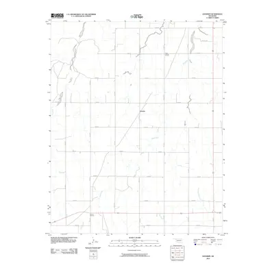
2010 Map of Goodwin
USGS Topo · Published 2010About this map
Goodwin anchors this section of Ellis County, Oklahoma, positioned within a landscape defined by a regular grid of section roads and several drainage systems. The area is characterized by its agricultural layout, punctuated by the winding paths of Rock Creek and Long Creek. Local history and genealogy are anchored by two distinct burial sites: the Christ Lutheran Cemetery in the northern portion of the quadrangle and Emmons Cemetery to the southwest near Coon Creek. The presence of Oil Field Rd in the northeast indicates the local intersection of ranching or farming with energy extraction. This survey illustrates how the high plains topography is managed through a strict rectangular survey system, even as West Red Bluff Creek and Hog Creek create natural breaks in the geometric pattern of roads like N 1720 Rd and E 0560 Rd.
Find a feature on this map
25 named features on this map. Tap any name to fly to it.
Don’t see what you’re looking for? This feature index may not catch every label — zoom into the map to look around manually.
Map Details
Editions of this 2010 Goodwin Map
This is the sole edition of this map. No revisions or reprints were ever made.
Other maps of this area

1954 · Perryton
USGS Topo · 1:250,000

1955 · Woodward
USGS Topo · 1:250,000

1958 · Perryton
USGS Topo · 1:250,000

1958 · Woodward
USGS Topo · 1:250,000

1969 · Shattuck
USGS Topo · 1:24,000

1969 · Gage
USGS Topo · 1:24,000

1970 · Arnett
USGS Topo · 1:24,000

1970 · Arnett SE
USGS Topo · 1:24,000
1970 · Arnett SW
USGS Topo · 1:24,000

1970 · Goodwin
USGS Topo · 1:24,000