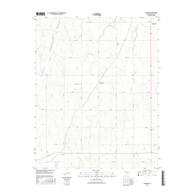
2016 Map of Goodwin
USGS Topo · Published 2016About this map
Goodwin and its surrounding rural prairie landscape are the focus of this 2016 Oklahoma survey. Situated in the High Plains region of Ellis County, the area is defined by its agricultural grid and the subtle drainage networks of Rock Cr and W Red Bluff Cr. The map captures a high degree of detail for genealogists and local historians, particularly through the preservation of rural burial sites. Small family and congregational grounds like Emmons Cem, Christ Lutheran Cem, and Ebenezer Baptist Cem are clearly marked, providing physical anchors to the pioneer communities that once clustered around these prairie crossroads. To the northeast, the outskirts of Shattuck appear, while the rest of the quadrangle is interconnected by a systematic network of section-line roads, including e0550 RD and NS 173, illustrating the enduring spatial organization of Oklahoma's ranching and farming country.
Find a feature on this map
40 named features on this map. Tap any name to fly to it.
Don’t see what you’re looking for? This feature index may not catch every label — zoom into the map to look around manually.
Map Details
Editions of this 2016 Goodwin Map
This is the sole edition of this map. No revisions or reprints were ever made.
Other maps of this area

1954 · Perryton
USGS Topo · 1:250,000

1955 · Woodward
USGS Topo · 1:250,000

1958 · Perryton
USGS Topo · 1:250,000

1958 · Woodward
USGS Topo · 1:250,000

1969 · Shattuck
USGS Topo · 1:24,000

1969 · Gage
USGS Topo · 1:24,000

1970 · Arnett
USGS Topo · 1:24,000

1970 · Arnett SE
USGS Topo · 1:24,000
1970 · Arnett SW
USGS Topo · 1:24,000

1970 · Goodwin
USGS Topo · 1:24,000