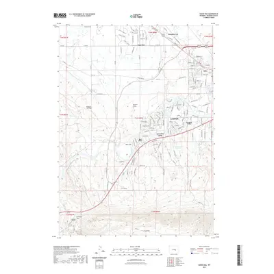
2021 Map of Goose Egg
USGS Topo · Published 2021About this map
The North Platte River winds through the heart of this Wyoming landscape, defining the transition from the expanding residential suburbs of Casper to the open rangeland and dramatic topography of the southern frontier. The map captures the interface between modern development in communities like Paradise Valley and Red Buttes Village and the area's deep historical roots, most notably marked by the Red Buttes Burial Ground. To the south, the terrain rises sharply toward the northern face of Casper Mtn, where the deep incision of Jackson Canyon and Gotheberg Draw create a stark contrast to the flatter northern sections around Vista West. This 2021 survey details an intricate network of local roads and draws, such as Sixmile Draw and Webb Draw, which underscore the drainage patterns essential to this high-plains environment.
Find a feature on this map
154 named features on this map. Tap any name to fly to it.
Don’t see what you’re looking for? This feature index may not catch every label — zoom into the map to look around manually.
Map Details
Editions of this 2021 Goose Egg Map
This is the sole edition of this map. No revisions or reprints were ever made.
Other maps of this area

1950 · Emigrant Gap
USGS Topo · 1:24,000

1950 · Goose Egg
USGS Topo · 1:24,000

1950 · Emigrant Gap NE
USGS Topo · 1:24,000

1951 · The Reefs
USGS Topo · 1:24,000

1951 · Casper
USGS Topo · 1:24,000

1951 · Bessemer Mountain
USGS Topo · 1:24,000

1952 · Bishop
USGS Topo · 1:24,000

1955 · Casper
USGS Topo · 1:250,000

1958 · Casper
USGS Topo · 1:250,000
1960 · Emigrant Gap
USGS Topo · 1:24,000