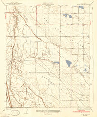
1931 Map of Goose Lake
USGS Topo · Published 1939About this map
Indian Burial Mounds dot the landscape of the southern San Joaquin Valley in this survey, showing a cultural history that predates the extensive irrigation systems developed here. The terrain is defined by the dry Goose Lake Bed and the prominent Semitropic Ridge, which rise above a network of man-made waterways. During this era, the region transitioned toward large-scale agriculture, as evidenced by the Goose Lake Canal, Eastside Canal, and Westside Canal that cut through the arid flats.
Find a feature on this map
16 named features on this map. Tap any name to fly to it.
Don’t see what you’re looking for? This feature index may not catch every label — zoom into the map to look around manually.
Map Details
Editions of this 1931 Goose Lake Map
2 editions found
Other maps of this area

1910 · Buena Vista Lake
USGS Topo · 1:125,000

1912 · McKittrick
USGS Topo · 1:125,000

1912 · Buena Vista Lake
USGS Topo · 1:125,000

1914 · Lost Hills
USGS Topo · 1:125,000

1927 · Semitropic
USGS Topo · 1:31,680

1930 · Leonards
USGS Topo · 1:31,680

1930 · Hamlin School
USGS Topo · 1:31,680

1930 · Miramonte Ranch
USGS Topo · 1:31,680

1931 · Lokern
USGS Topo · 1:31,680

1931 · Goose Lake
USGS Topo · 1:31,680