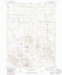
1981 Map of Goose Lake SW
USGS Topo · Published 1986About this map
The Nebraska Sandhills landscape across the Holt Co Wheeler Co line is defined by its subtle drainage patterns and subsurface water resources as they appeared in the early 1980s. The presence of numerous Flowing Wells and individual Flowing Well labels throughout the northern sections suggests a significant reliance on the underlying aquifer for ranching and agricultural operations. Cache Creek meanders through the central terrain, while the southern portion of the quadrangle opens into the broad expanse of Buffalo Flats. Genealogical interest centers on Farmers Hill Cem and Conley Cem, both located near the local high point of Farmers Hill. The map detail includes an extensive network of fence and field lines, updated during the 1986 photorevision process to reflect contemporary land use in this Nebraska cattle country.
Find a feature on this map
14 named features on this map. Tap any name to fly to it.
Don’t see what you’re looking for? This feature index may not catch every label — zoom into the map to look around manually.
Map Details
Editions of this 1981 Goose Lake SW Map
2 editions found
Other maps of this area

1954 · Bartlett NW
USGS Topo · 1:24,000

1954 · Bartlett
USGS Topo · 1:24,000

1954 · Gables
USGS Topo · 1:24,000

1955 · Broken Bow
USGS Topo · 1:250,000

1955 · O'Neill
USGS Topo · 1:250,000

1956 · Broken Bow
USGS Topo · 1:250,000

1959 · O'Neill
USGS Topo · 1:250,000

1969 · O'Neill
USGS Topo · 1:250,000

1981 · Goose Lake SW
USGS Topo · 1:24,000

1981 · Chambers East
USGS Topo · 1:24,000