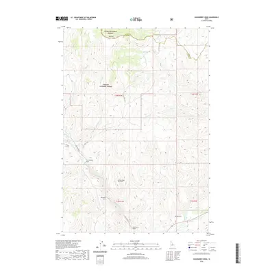
2020 Map of Gooseberry Creek
USGS Topo · Published 2020About this map
The Salmon River Mountains dominate this high-elevation landscape, where the administrative boundaries of Challis National Forest and Salmon National Forest meet. The terrain is defined by a dense network of drainages and gulches, including First Crossing Gulch, Boneyard Gulch, and Mud Spring Gulch, which funnel water toward larger tributaries like Morgan Cr and the Salmon River itself. A prominent topographical feature, Table Mtn, stands near the boundary line between Lemhi Co and Custer Co. Access through this mountain environment is primarily facilitated by the Morgan Creek Rd and the Nat For Dev Rd 056, illustrating the primary transportation corridors used for forest management and local transit through the drainage basins of Gooseberry Cr and Ellis Cr.
Find a feature on this map
24 named features on this map. Tap any name to fly to it.
Don’t see what you’re looking for? This feature index may not catch every label — zoom into the map to look around manually.
Map Details
Editions of this 2020 Gooseberry Creek Map
This is the sole edition of this map. No revisions or reprints were ever made.
Other maps of this area

1956 · Challis
USGS Topo · 1:62,500

1956 · Twin Peaks
USGS Topo · 1:62,500

1957 · Challis
USGS Topo · 1:250,000

1960 · Challis
USGS Topo · 1:250,000

1963 · Challis
USGS Topo · 1:250,000
1963 · Black Mtn
USGS Topo · 1:24,000
1963 · Hat Creek
USGS Topo · 1:24,000
1963 · Wards Butte
USGS Topo · 1:24,000
1982 · Challis
USGS Topo · 1:100,000
1989 · Grouse Peak
USGS Topo · 1:24,000