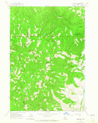
1963 Map of Black Mtn
USGS Topo · Published 1965About this map
Salmon National Forest and Challis National Forest converge in this high-altitude landscape of central Idaho. The terrain is defined by a series of prominent summits including Black Mtn, Woods Peak, and Van Horn Peak, which anchor a complex drainage system flowing into Panther Creek and Morgan Creek. The presence of Arrastra Creek suggests the area's history of placer mining, as an arrastra was a primitive mill used for grinding ore. Evidence of early habitation and land use is sparse but significant, centered on the Oyler Ranch near the southeastern corner and various jeep trails that navigate the ridges. Key landmarks such as Morgan Creek Summit and Cougar Lake provide navigational points within the dense network of gulches like Smith Gulch and Hogan Gulch. The 1963 field check records the transitional forest boundaries and seasonal water sources identified as Springs throughout the range.
Find a feature on this map
30 named features on this map. Tap any name to fly to it.
Don’t see what you’re looking for? This feature index may not catch every label — zoom into the map to look around manually.
Map Details
Editions of this 1963 Black Mtn Map
2 editions found
Other maps of this area

1956 · Challis
USGS Topo · 1:62,500

1956 · Twin Peaks
USGS Topo · 1:62,500

1957 · Challis
USGS Topo · 1:250,000

1960 · Challis
USGS Topo · 1:250,000

1963 · Challis
USGS Topo · 1:250,000
1963 · Opal Lake
USGS Topo · 1:24,000
1963 · Duck Creek Point
USGS Topo · 1:24,000
1963 · Taylor Mountain
USGS Topo · 1:24,000
1963 · Wards Butte
USGS Topo · 1:24,000
1963 · Meyers Cove Point
USGS Topo · 1:24,000