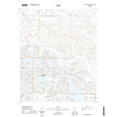
2020 Map of Goosepond Mountain
USGS Topo · Published 2020About this map
Hot Springs Village dominates this 2020 landscape, showcasing a complex network of residential streets and recreational lakes carved into the Ouachita foothills. The map reveals the intricate development patterns surrounding Lake Coronado, Lake Cortez, and Lake Pineda, where hundreds of named ways and circles define the planned community's layout. This modern suburban density contrasts sharply with the northern sections of the map, where the terrain rises toward Goosepond Mtn and Howard Mtn. These upland areas are largely defined by timber management roads like Weyerhaeuser 24240 and Weyerhaeuser 24710, tracing the drainage of the Middle Fork Saline River and its tributaries. Near the southern boundary, the settlement of Fountain Lake sits at a geographic transition, while the presence of the Talley Cem to the northwest provides a point of historical continuity amidst the significant 21st-century growth.
Find a feature on this map
272 named features on this map. Tap any name to fly to it.
Don’t see what you’re looking for? This feature index may not catch every label — zoom into the map to look around manually.
Map Details
Editions of this 2020 Goosepond Mountain Map
This is the sole edition of this map. No revisions or reprints were ever made.
Other maps of this area

1890 · Benton
USGS Topo · 1:125,000

1890 · Hot Springs
USGS Topo · 1:125,000

1894 · Hot Springs
USGS Topo · 1:125,000

1894 · Benton
USGS Topo · 1:125,000

1955 · Little Rock
USGS Topo · 1:250,000

1956 · Little Rock
USGS Topo · 1:250,000

1960 · Little Rock
USGS Topo · 1:250,000

1963 · Paron SW
USGS Topo · 1:24,000

1963 · Paron
USGS Topo · 1:24,000

1964 · Little Rock
USGS Topo · 1:250,000