
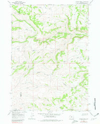
1967 Map of Gordon Creek
USGS Topo · Published 1971About this map
The Middle Fork Powder River carves through this high-country landscape where Johnson, Washakie, and Natrona Counties meet. The 1967 survey reveals a remote terrain defined by a dense network of drainages, including the headwaters of Bachaus Creek, Sullivan Creek, and Roush Creek. Evidence of ranching and land use is sparse but specific, marked by a lonely Corral and a station noted as WC. Transport is limited to rugged tracks like the Jeep Trail that follows the ridges near North Poker Creek and Carpenter Creek. This map captures a moment of topographical stability in the Wyoming backcountry, where family-named features like Stubbs Creek and the heights of Middlefork suggest the long history of livestock grazing and open-range land management in the Powder River Basin headwaters.
Find a feature on this map
26 named features on this map. Tap any name to fly to it.
Don’t see what you’re looking for? This feature index may not catch every label — zoom into the map to look around manually.
Map Details
Editions of this 1967 Gordon Creek Map
2 editions found
Other maps of this area

1952 · Grave Spring
USGS Topo · 1:24,000

1955 · Arminto
USGS Topo · 1:250,000

1958 · Arminto
USGS Topo · 1:250,000

1961 · Barnum
USGS Topo · 1:62,500

1962 · Arminto
USGS Topo · 1:250,000

1967 · Horse Butte
USGS Topo · 1:24,000

1967 · Turk Springs
USGS Topo · 1:24,000
1967 · Cherry Creek Hill
USGS Topo · 1:24,000

1968 · First Water Draw
USGS Topo · 1:24,000

1968 · Roughlock Hill
USGS Topo · 1:24,000