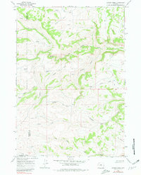
1967 Map of Gordon Creek
USGS Topo · Published 1980About this map
The South Fork Powder River and Middle Fork Powder River carve through the high country of central Wyoming, where the boundaries of Washakie, Johnson, and Natrona counties converge. This 1967 survey captures a remote landscape defined by a complex network of drainage basins, including Gordon Creek, Sullivan Creek, and Blue Prong Creek. The absence of developed towns emphasizes the area's use for ranching and resource management, with fine red dashed lines indicating fence lines that segment the high plains and slopes like Dry Vee Slope and North Slope.
Find a feature on this map
20 named features on this map. Tap any name to fly to it.
Don’t see what you’re looking for? This feature index may not catch every label — zoom into the map to look around manually.
Map Details
Editions of this 1967 Gordon Creek Map
2 editions found
Other maps of this area

1952 · Grave Spring
USGS Topo · 1:24,000

1955 · Arminto
USGS Topo · 1:250,000

1958 · Arminto
USGS Topo · 1:250,000

1961 · Barnum
USGS Topo · 1:62,500

1962 · Arminto
USGS Topo · 1:250,000

1967 · Horse Butte
USGS Topo · 1:24,000

1967 · Gordon Creek
USGS Topo · 1:24,000

1967 · Turk Springs
USGS Topo · 1:24,000
1967 · Cherry Creek Hill
USGS Topo · 1:24,000

1968 · First Water Draw
USGS Topo · 1:24,000