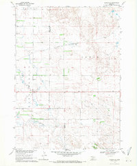
1969 Map of Gordon SE
USGS Topo · Published 1971About this map
The Chicago and North Western railroad cuts across the Sandhills landscape of this 1969 survey, tracing a path through the transition between Sheridan and Cherry counties. This interior ranching region is defined by the winding courses of Antelope Creek and Hay Creek, which support the scattered agricultural operations visible in the fine red dashed fence and field lines. The map documents the localized social infrastructure of rural Nebraska, identifying several small educational hubs including Sunny Knoll Sch, East Pride Sch, and Northwest Cherry Sch. In the northern portion of the sheet, the label Wounded Knee marks a prominent water feature near the regional divide. The presence of a Gravel Pit along the rail line suggests the localized extraction industry supporting the transport network and road development in this sparsely populated cattle country.
Find a feature on this map
12 named features on this map. Tap any name to fly to it.
Don’t see what you’re looking for? This feature index may not catch every label — zoom into the map to look around manually.
Map Details
Editions of this 1969 Gordon SE Map
This is the sole edition of this map. No revisions or reprints were ever made.
Other maps of this area

1950 · Irwin
USGS Topo · 1:62,500

1951 · Irwin
USGS Topo · 1:62,500

1951 · Gypsy Valley
USGS Topo · 1:62,500

1955 · Alliance
USGS Topo · 1:250,000

1957 · Alliance
USGS Topo · 1:250,000

1957 · Valentine
USGS Topo · 1:250,000

1958 · Alliance
USGS Topo · 1:250,000

1959 · Valentine
USGS Topo · 1:250,000

1969 · Gordon
USGS Topo · 1:24,000
1969 · Rushville 4 NE
USGS Topo · 1:24,000