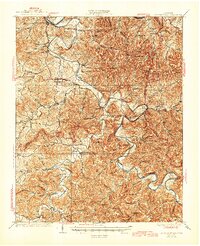
1928 Map of Gordonsville
USGS Topo · Published 1945About this map
The Cumberland River and Caney Fork dictate the settlement patterns of this Middle Tennessee region, where water transport and rail access defined community life in the late 1920s. Along the winding Caney Fork, distinct topographical features like Bettys Bend and Moccasin Bluff shape the landscape between Gordonsville and Lancaster. The Tennessee Central railroad cuts through the terrain, connecting towns like Hickman to larger hubs.
Find a feature on this map
123 named features on this map. Tap any name to fly to it.
Don’t see what you’re looking for? This feature index may not catch every label — zoom into the map to look around manually.
Map Details
Editions of this 1928 Gordonsville Map
2 editions found
Other maps of this area

1893 · Mc Minnville
USGS Topo · 1:125,000

1895 · Mc Minnville
USGS Topo · 1:125,000

1908 · Woodbury
USGS Topo · 1:62,500

1925 · Gainesboro
USGS Topo · 1:62,500

1928 · Gordonsville
USGS Topo · 1:62,500

1929 · Gainesboro
USGS Topo · 1:62,500

1932 · Carthage
USGS Topo · 1:62,500

1942 · Statesville
USGS Topo · 1:100,000

1943 · Cookeville
USGS Topo · 1:100,000

1944 · Cookeville
USGS Topo · 1:100,000