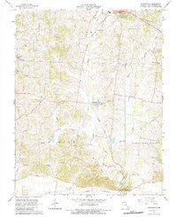
1967 Map of Gordonville
USGS Topo · Published 1984About this map
Hubble Creek and its many tributaries, including Goose Creek and Williams Creek, carve a rolling landscape through central Cape Girardeau County. The Missouri Pacific railroad corridor serves as a primary transit spine, connecting the northern settlement of Jackson to the crossroads at Gordonville and southward to Dutchtown. This 1967 survey reveals a deeply established rural community defined by its family and congregational centers, evidenced by numerous burial grounds like McGuire Cem and Summers Cem alongside local landmarks such as Oak Grove Sch. Small clusters like Tilsit and Helderman dot the western hills, while the southern reaches near the Missouri Pacific line show the transition into the flatter terrain of the Mississippi floodplain. The presence of the Kimbeland Country Club and early Highland Drive developments near Jackson indicate the early stages of suburban expansion in an otherwise agrarian region.
Find a feature on this map
40 named features on this map. Tap any name to fly to it.
Don’t see what you’re looking for? This feature index may not catch every label — zoom into the map to look around manually.
Map Details
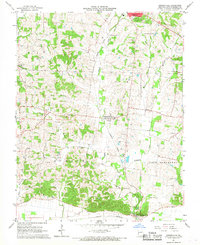
Editions of this 1967 Gordonville Map
2 editions found
Other maps of this area

1922 · Cape Girardeau
USGS Topo · 1:62,500

1924 · Cape Girardeau
USGS Topo · 1:62,500

1933 · Marble Hill
USGS Topo · 1:62,500

1934 · Morley
USGS Topo · 1:62,500

1934 · Advance
USGS Topo · 1:62,500

1937 · Marble Hill
USGS Topo · 1:62,500

1939 · Morley
USGS Topo · 1:62,500

1939 · Advance
USGS Topo · 1:62,500

1949 · Paducah
USGS Topo · 1:250,000

1950 · Paducah
USGS Topo · 1:250,000