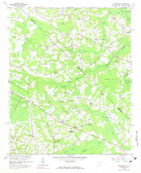
1962 Map of Goretown
USGS Topo · Published 1975About this map
Goretown and Grahams Crossroads anchor this coastal plain landscape along the North Carolina South Carolina border during the early 1960s. The terrain is defined by a complex network of wetlands and creeks, including the extensive Juniper Swamp, Wild Cattle Swamp, and Sheepbridge Swamp. This survey reveals a community deeply rooted in its local institutions, evidenced by the high density of rural churches and family-named cemeteries such as Ironhill Ch, Sweet Gum Ch, and Soles Cem.
Find a feature on this map
56 named features on this map. Tap any name to fly to it.
Don’t see what you’re looking for? This feature index may not catch every label — zoom into the map to look around manually.
Map Details
Editions of this 1962 Goretown Map
2 editions found
Other maps of this area

1937 · Nixonville
USGS Topo · 1:48,000

1942 · Nixonville
USGS Topo · 1:62,500

1943 · Pireway
USGS Topo · 1:31,680

1943 · Nakina
USGS Topo · 1:24,000

1944 · Longs
USGS Topo · 1:31,680

1949 · Georgetown
USGS Topo · 1:250,000

1953 · Longs
USGS Topo · 1:24,000
1953 · Pireway
USGS Topo · 1:24,000

1953 · Florence
USGS Topo · 1:250,000

1954 · Florence
USGS Topo · 1:250,000