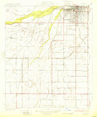
1932 Map of Gosford
USGS Topo · Published 1932About this map
The Kern River and its complex network of man-made irrigation channels define this San Joaquin Valley landscape just south of Bakersfield. In the early 1930s, the region was heavily partitioned by agricultural development, with the Buena Vista Canal, Stine Canal, and James Canal cutting across the terrain to support local ranching and farming operations. The layout reveals the essential role of water management in transforming the arid valley floor into productive land, as seen near Bellevue Ranch and the Stockdale Country Club.
Find a feature on this map
37 named features on this map. Tap any name to fly to it.
Don’t see what you’re looking for? This feature index may not catch every label — zoom into the map to look around manually.
Map Details
Editions of this 1932 Gosford Map
3 editions found
Other maps of this area

1906 · Bakersfield
USGS Topo · 1:62,500

1910 · Buena Vista Lake
USGS Topo · 1:125,000

1912 · Buena Vista Lake
USGS Topo · 1:125,000

1914 · Caliente
USGS Topo · 1:125,000

1929 · Stevens
USGS Topo · 1:31,680

1929 · Fairfax School
USGS Topo · 1:31,680

1930 · Weed Patch
USGS Topo · 1:31,680

1930 · Millux
USGS Topo · 1:31,680

1930 · Rosedale
USGS Topo · 1:31,680

1930 · Conner
USGS Topo · 1:31,680