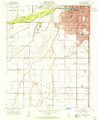
1954 Map of Gosford
USGS Topo · Published 1955About this map
The Kern River and an intricate network of irrigation channels like the Gates Canal and Stockdale Canal define the agricultural landscape of the southern San Joaquin Valley in the mid-1950s. This survey captures the southwest expansion of Bakersfield, where residential blocks begin to press against established agricultural sites such as the Stockdale Ranch and the Stockdale Country Club. Further south, rural communities like Pumpkin Center, Old River, and Panama are visible as small clusters of activity along the grid-like road system.
Find a feature on this map
59 named features on this map. Tap any name to fly to it.
Don’t see what you’re looking for? This feature index may not catch every label — zoom into the map to look around manually.
Map Details
Editions of this 1954 Gosford Map
3 editions found
Other maps of this area

1906 · Bakersfield
USGS Topo · 1:62,500

1910 · Buena Vista Lake
USGS Topo · 1:125,000

1912 · Buena Vista Lake
USGS Topo · 1:125,000

1914 · Caliente
USGS Topo · 1:125,000

1929 · Stevens
USGS Topo · 1:31,680

1929 · Fairfax School
USGS Topo · 1:31,680

1930 · Weed Patch
USGS Topo · 1:31,680

1930 · Millux
USGS Topo · 1:31,680

1930 · Rosedale
USGS Topo · 1:31,680

1930 · Conner
USGS Topo · 1:31,680