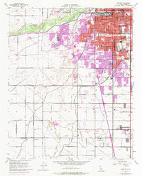
1954 Map of Gosford
USGS Topo · Published 1976About this map
Bakersfield expands southward into the San Joaquin Valley, where mid-century urban growth meets an intricate network of irrigation and industry. The landscape is defined by the heavy infrastructure of the Fruitvale Oil Field and numerous oil wells to the north, contrasted against the agricultural legacies of Wible Orchard and Stockdale Ranch. Significant transit corridors like the Southern Pacific railroad and Taft Highway connect small outlying settlements such as Pumpkin Center, Old River, and Greenfield (Delkern PO).
Find a feature on this map
88 named features on this map. Tap any name to fly to it.
Don’t see what you’re looking for? This feature index may not catch every label — zoom into the map to look around manually.
Map Details
Editions of this 1954 Gosford Map
3 editions found
Other maps of this area

1906 · Bakersfield
USGS Topo · 1:62,500

1910 · Buena Vista Lake
USGS Topo · 1:125,000

1912 · Buena Vista Lake
USGS Topo · 1:125,000

1914 · Caliente
USGS Topo · 1:125,000

1929 · Stevens
USGS Topo · 1:31,680

1929 · Fairfax School
USGS Topo · 1:31,680

1930 · Weed Patch
USGS Topo · 1:31,680

1930 · Millux
USGS Topo · 1:31,680

1930 · Rosedale
USGS Topo · 1:31,680

1930 · Conner
USGS Topo · 1:31,680