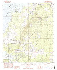
1982 Map of Goshen Springs
USGS Topo · Published 1983About this map
Goshen Springs and Fannin anchor this 1980s landscape, illustrating the transition from rural crossroads to a region increasingly defined by the Ross R Barnett Reservoir. The map documents a community infrastructure rooted in faith and education, specifically through landmarks like Pisgah Sch and a cluster of local churches such as New Truelight Ch and Shady Grove Ch. The influence of the Pearl River is central here, with Pelahatchie Bay and Plummer Slu carving through the southern terrain.
Find a feature on this map
29 named features on this map. Tap any name to fly to it.
Don’t see what you’re looking for? This feature index may not catch every label — zoom into the map to look around manually.
Map Details
Editions of this 1982 Goshen Springs Map
This is the sole edition of this map. No revisions or reprints were ever made.
Other maps of this area

1903 · Jackson
USGS Topo · 1:125,000

1905 · Jackson
USGS Topo · 1:48,000

1908 · Jackson
USGS Topo · 1:62,500

1922 · Pelahatchee
USGS Topo · 1:48,000

1924 · Pelahatchee
USGS Topo · 1:62,500

1950 · Pelahatchie
USGS Topo · 1:62,500

1952 · Pelahatchie
USGS Topo · 1:62,500

1953 · Meridian
USGS Topo · 1:250,000

1955 · Jackson
USGS Topo · 1:250,000

1957 · Meridian
USGS Topo · 1:250,000