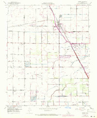
1949 Map of Goshen
USGS Topo · Published 1971About this map
The agricultural landscape of the San Joaquin Valley centers on Goshen and the surrounding irrigation network that defines Tulare County life. Revised in 1949 and later updated in 1969, the map reveals a highly structured environment where natural watercourses like Cross Creek and Packwood Creek are augmented by a complex system of human-made infrastructure, including the Modoc Ditch, Persian Ditch, and the Tagus Irrigation Canal. This water management supports a series of labor settlements and worker communities, identified as Camp Three, Camp Seven, and Camp Eleven, illustrating the industrial scale of local farming operations.
Find a feature on this map
39 named features on this map. Tap any name to fly to it.
Don’t see what you’re looking for? This feature index may not catch every label — zoom into the map to look around manually.
Map Details
Editions of this 1949 Goshen Map
This is the sole edition of this map. No revisions or reprints were ever made.
Other maps of this area

1925 · Tulare
USGS Topo · 1:31,680

1926 · Goshen
USGS Topo · 1:31,680

1926 · Burris Park
USGS Topo · 1:31,680

1927 · Traver
USGS Topo · 1:31,680

1927 · Monson
USGS Topo · 1:31,680

1927 · Remnoy
USGS Topo · 1:31,680

1927 · Paige
USGS Topo · 1:31,680

1927 · Visalia
USGS Topo · 1:31,680

1927 · Tulare
USGS Topo · 1:31,680

1928 · Waukena
USGS Topo · 1:31,680